Bad Data In Equals Bad Data Out - The Importance of Survey
In Ultra-Wideband (UWB) Real-Time Location Systems (RTLS), location tracking performance depends heavily on the accuracy of the physical setup. UWB signals can deliver sub-centimeter capability under ideal conditions. However, the mathematical calculations performed by the tracking engine are only as reliable as the baseline input data. A good computer scientist will tell you, “Garbage in, Garbage out!”
At the heart of any reliable CUWB deployment is the anchor survey, a fundamental process that establishes a 3D coordinate system for the tracking area. When configuring an indoor positioning system, the anchor array is installed, physically measured, and then the coordinates are entered into the CUWB Manager. Errors in anchor locations directly translate into errors in position output, severely impacting overall performance, reliability, and precision.
Distinguishing Accuracy vs. Precision
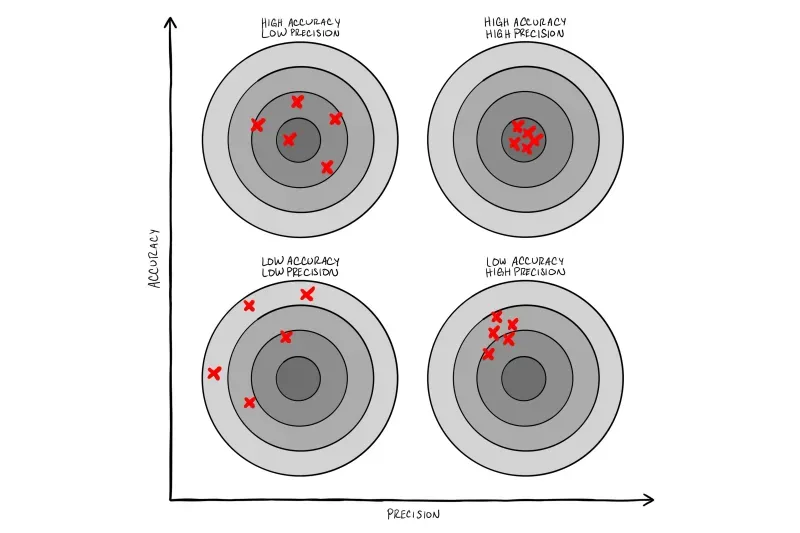
To understand why surveying matters, it is vital to distinguish between accuracy and precision:
Accuracy (Truth): The deviation of a reported tag position from its actual physical location in the real world. Accuracy is primarily a function of installation quality, physical survey measurements, and environmental conditions.
Precision (Repeatability): The variation, or noise/jitter, in repeated position measurements of a stationary or moving tag. Precision can be improved through smoothing and proper anchor placement.
If an anchor’s survey coordinates are entered incorrectly into the system, every tag calculation derived using that anchor will suffer from a static bias. While the system may display high precision (low jitter), the reported location will be offset from physical reality.
Impact of Anchor Geometry and Density
Anchor placement and geometry directly influence spatial error through Geometric Dilution of Precision (GDoP). See our Application Note APD009: Accuracy and Precision for a deeper look at the impacts of anchor geometry and smoothing on CUWB Location data output.
Preventing High GDoP: When anchors are clustered closely together or installed in a strict straight line, position intersections become elongated, dramatically magnifying error. Surrounding the perimeter and distributing anchors across the space improves GDoP, locking tag positions into a tight solution.
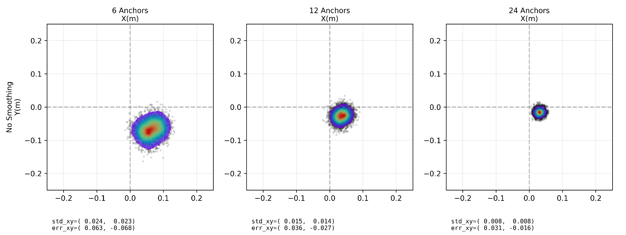
Increasing Anchor Density: Empirical benchmark data shows that expanding the participating anchor array directly improves both precision and absolute accuracy:
6 Anchors: Raw precision standard deviation ~ 2.3 cm, average accuracy error ~6.8 cm.
12 Anchors: Raw precision standard deviation drops to ~1.5 cm, with average accuracy error of ~3.1 cm.
24 Anchors: Raw precision reaches sub-centimeterlevel~0.8 cm, with the average accuracy error reduced to ~2.3 cm.
High anchor density also provides resilience to occlusion. If line-of-sight (LoS) to several anchors is blocked by heavy machinery or structural barriers, higher anchor counts allow the CUWB Engine to de-weight Non-LoS signals and preserve tracking accuracy.
The Mechanics of Anchor Surveys
The survey process establishes a 3D coordinate system for the entire tracking area.
Defining the Coordinate System: Establish a clear origin point (0,0,0) and align X, Y, and Z axes with the floor plan.
Accounting for Measurement Offsets: The AN302 anchors have designated physical survey points with a fixed offset relative to the antenna. These offsets should be taken into account when measuring to the survey point.
Height Variation and Angular Diversity:The best performance is achieved when the CUWB location engine has angular diversity between the tag and the anchors. Consider placing anchors at different heights and directly above key areas of interest.
Anchor survey should rely on a fixed, immutable baseline for the origin point that can be easily identified and measured against. It is highly recommended to use precision measurement equipment, such as a total station or LiDAR survey. If dedicated survey equipment isn’t available, a plumb bob can be used to translate anchor positions to marks on the floor then manually surveyed using a tape measure. Regardless of the methodology, the survey should be carefully checked and common errors should be avoided.
Identifying Common Survey Errors
Even small mistakes during deployment can distort location output. Understanding how survey mistakes manifest in the system helps users troubleshoot anomalies quickly. Here are three common issues:
Large Single-Anchor Offset: A meter error in a single anchor can cause tags to track normally in non-affected regions, diverge significantly near corners, and gradually re-converge as that anchor's contribution tapers off.
Systemic Imprecise Survey: Minor errors across multiple anchors can produce slight, persistent offsets and spatial distortions across the tracking area.
Swapped Serial Numbers: Reversing two anchor serial numbers during coordinate entry can lead to severe positioning anomalies, including discontinuities, mirrored movements, or travel backward relative to physical motion.
Troubleshooting Tools
To validate survey data, leverage built-in utilities provided by CUWB tools:
Visual Inspection in CUWB Viewer: Verify that the 3D rendered anchor positions in the viewer match real-world physical placement relative to walls and architectural boundaries.
Distance Measurement Tool: Use CUWB Manager's built-in measurement features to double-check dimensions between anchors and eliminate manual survey entry typos.
LED Identification: Trigger specific anchor LED color patterns from CUWB Manager to confirm physical device serial numbers match software map assignments.
Anchor Walk & Test Patterns: Carry a tag along a predictable test path (e.g., a clockwise circle) and walk near each individual anchor. Path distortions or unnatural pushing effects during an anchor walk immediately highlight serial number swaps or mis-surveyed coordinates.
Conclusion & Resources
A precise anchor survey is the foundation of high-performance Ultra-Wideband Indoor Positioning Systems. By combining careful survey techniques with strategic anchor placement, deployments achieve maximum precision, accuracy, and operational performance.
For step-by-step guides, planning utilities, and application notes, visit the official documentation: